

Forget imposing checkpoints and stern guards! Some international borders take a wildly different approach. From surprisingly relaxed crossings to unexpected quirks, these unusual borders will leave you scratching your head…and reaching for your camera. Get ready to discover the world’s most peculiar frontiers.
Turtuk: A Sleepy Village Caught Between Nations
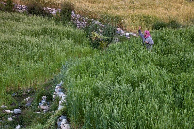
Turtuk’s history is marked by conflict. Part of Pakistan after the 1947 partition, it was annexed by India during the 1971 war. Despite this tumultuous past, today Turtuk is a remote, peaceful farming village with its own distinct language, Balti. Ironically, its isolation wasn’t due to ongoing tensions, but rather Indian military restrictions meant to protect the border. Locals have since pushed back, desiring greater connection to the outside world.
Diomede Islands: Where the US and Russia Meet…and Time Takes a Leap
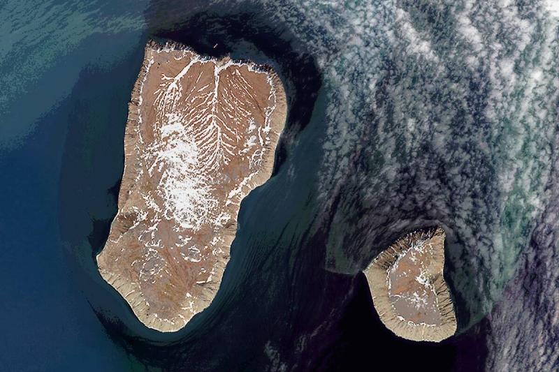
A mere 2.4 miles separate Little Diomede Island (US) and Big Diomede Island (Russia). From their Alaskan town, Little Diomede’s 82 residents can glimpse across the water to a Russian military base. But the strangeness doesn’t end there! The International Date Line runs between these islands, creating a 21-hour time difference despite their proximity.
The Golden Triangle: Where Beauty Masks a Troubled History
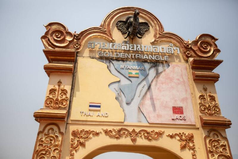
Nestled at the convergence of Thailand, Laos, and Myanmar, the Golden Triangle is a place of stunning natural beauty where the Mekong River marks the borders. Monuments highlight this geographic anomaly. However, this picturesque region harbors a darker past. Once infamous for opium production, the Golden Triangle remains a key smuggling route, now focused on synthetic drugs.
Usedom Island: Where History Meets Holiday on the German-Polish Border
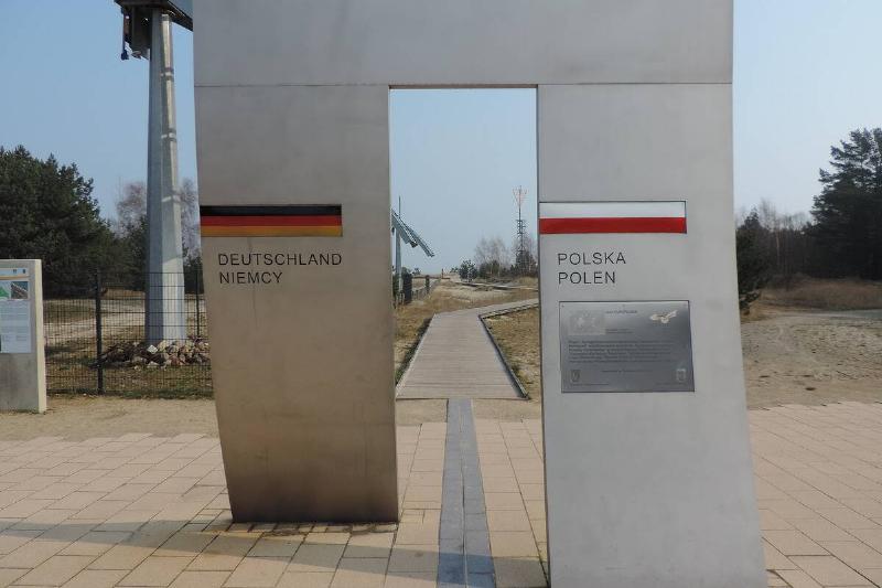
Usedom Island’s stunning beaches might seem an unlikely backdrop for a border crossing. However, this shared island is where Germany and Poland meet. Despite a complex history marked by World War II and the Cold War, today’s border is surprisingly fluid thanks to the Schengen Agreement and the European Union. As a popular tourist destination, monuments now mark the borderlines, offering a reminder of the past amidst a relaxed vacation atmosphere.
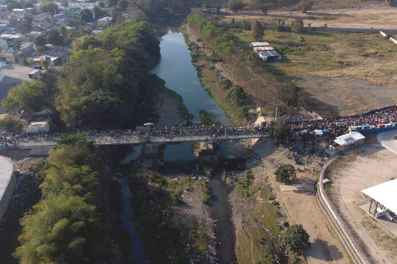
India and Bangladesh: A Border Puzzle…Solved
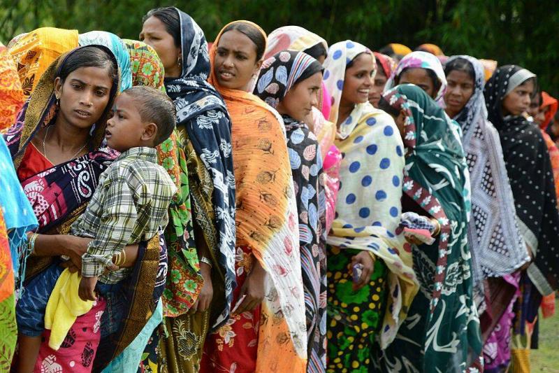
The Cooch Behar region was once a baffling maze of enclaves – pieces of one country surrounded by the other’s territory. Imagine needing a visa that legally didn’t exist, just to reach the local market! Fortunately, a 2011 agreement (ratified in 2015) has brought much-needed clarity to this tangled border between India and Bangladesh.
Baarle-Hertog/Baarle-Nassau: Where Borders Become a Game
A wrong turn in Baarle-Hertog (Belgium) or Baarle-Nassau (Netherlands) could land you in a whole new country! The messy aftermath of Belgium’s 1830 independence meant borders weren’t finalized until 1995, creating a delightful jumble of Belgian and Dutch territory. The border meanders through streets, squares, and even houses! It’s a place where crossing international borders becomes an accidental adventure.
Hispaniola’s Stark Divide: Where Borders Reveal an Environmental Crisis
Though they share an island, Haiti and the Dominican Republic are worlds apart – politically tense and facing stark environmental contrasts. Deforestation has ravaged the Haitian side of Hispaniola, creating a heartbreaking visual divide at the border. Satellite images expose the difference: lush Dominican forests give way to a more barren Haitian landscape. This border reveals more than just nations, it’s a stark reminder of an ongoing environmental crisis.
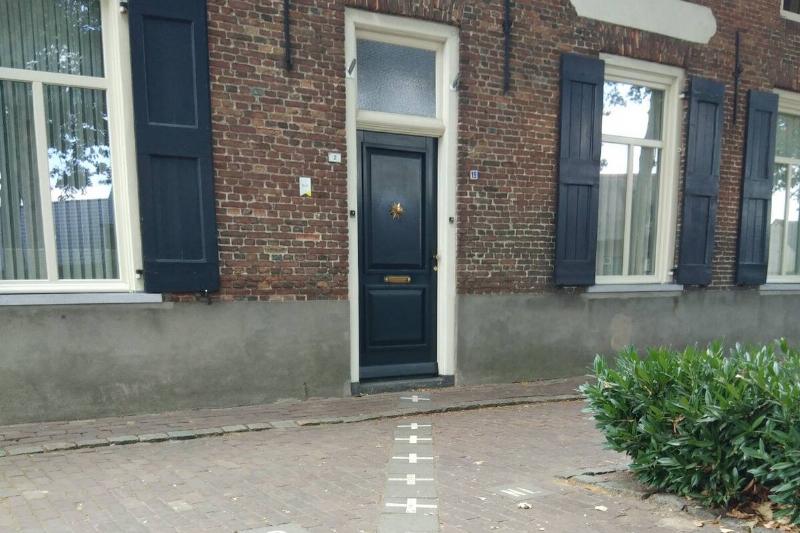
Haskell Library: Where a Black Line Divides Two Nations
Crossing the US-Canadian border usually means checkpoints, but not at the Haskell Library and Opera House! This unique building straddles the line between Derby Line, Vermont, and Stanstead, Quebec. Inside, a simple black tape marks the international boundary. Librarians are bilingual, and the library itself is divided: bookshelves mostly in Canada, the children’s reading area in the US. This is one border meant to be playfully crossed!
Exploring the DMZ: A Tourist Attraction in the Heart of Conflict
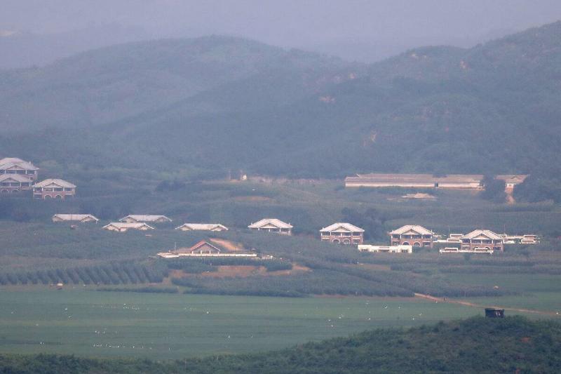
The Demilitarized Zone (DMZ) between North and South Korea stretches for 148 miles, a stark reminder of the Korean War’s unresolved legacy. Despite its name, the DMZ is heavily militarized on both sides, a barrier separating two nations technically still at war since 1953. Paradoxically, the DMZ has become a popular tourist destination, offering a glimpse into a tense and complex geopolitical reality.
Pheasant Island: Where France and Spain Take Turns
Nestled in the Bidasoa River, marking the French-Spanish border, lies Pheasant Island (whose name, ironically, is a mistranslation!). But its true oddity isn’t its lack of pheasants, but its shared ownership. Following the Treaty of the Pyrenees in 1648, France and Spain agreed to switch control of the island every six months! This unique arrangement stands as a testament to a history of conflict and cooperation.
Israel and Egypt
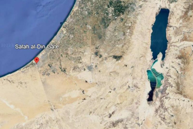
According to the South Florida Sun-Sentinel, this was the result of a massive and technologically advanced Israeli border wall built in 2013, which Bloomberg reported has since been used to fight extremist groups operating in Egypt’s Sinai Peninsula. But while that might suggest Egypt is displeased with the border wall, the reality is that this government has also found it useful from a security perspective and cooperates with the Israeli government in maintaining its effectiveness.
How Did The Gambia Get Its Shape?
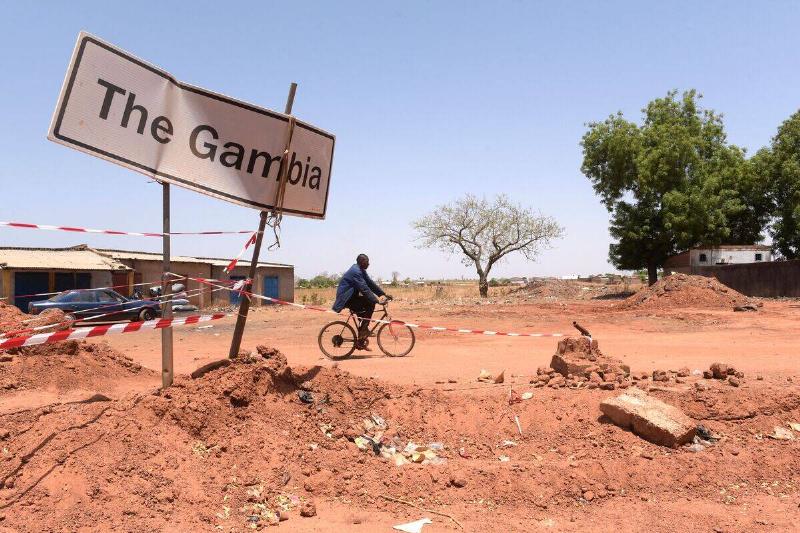
According to Atlas Obscura, The Gambia is a West African nation with some bizarre geography in that it’s a long, narrow nation that’s surrounded on three sides by Senegal, with only its western coast standing apart from the other African country. Although legend has it that the British created The Gambia by firing cannons up and down the Gambia River, the truth is a little more complicated. That’s because British colonial forces claimed the Gambia River and worked out some temporary borders with France after the French — who had colonial control over Senegal — recognized the British claim to the river. However, resistance from local rulers who didn’t appreciate having their land divided by European nations stymied further attempts to redraw the two nations’ borders beyond their current, odd circumstances.
Zipline Across Time Zones: Spain to Portugal
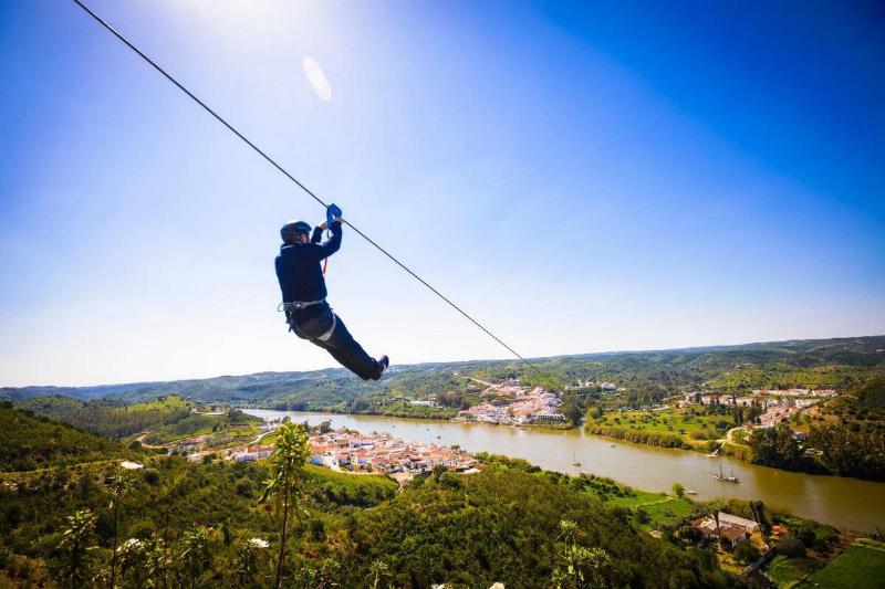
Spain and Portugal are separated by the River Guadiana, but the levels of elevation between the two nations in that area have allowed for an opportunity that isn’t available anywhere else. As the Limite Zero company behind this experience explained, it’s actually possible to take a zipline from Spain to Portugal. The journey sees riders travel about 787 yards at a minimum speed of 43 miles per hour, and when they land in Portugal, they find that time has gone backward by an hour. That’s because Spain and Portugal exist in different time zones. Sadly, Portugal’s lower elevation compared to Spain means travelers can’t zipline back, but there’s a ferry available instead.
Where Beauty and Conservation Meet: The Brazil-Argentina Border
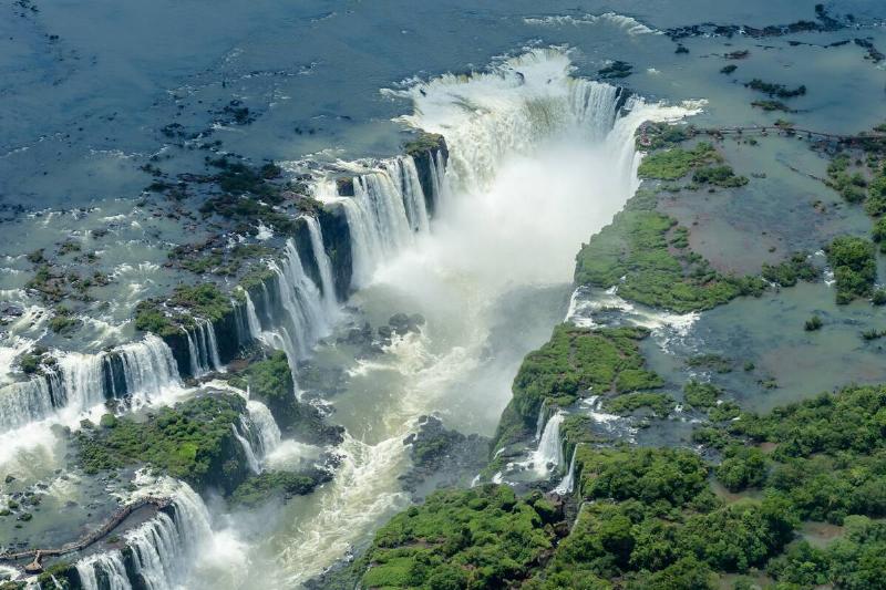
More than just a dividing line, the border between Brazil and Argentina is a natural masterpiece. The breathtaking Iguazú Falls, a UNESCO World Heritage Site, stands as a testament to the power and beauty of nature.
The Three-Country Cairn: Where Borders Blur
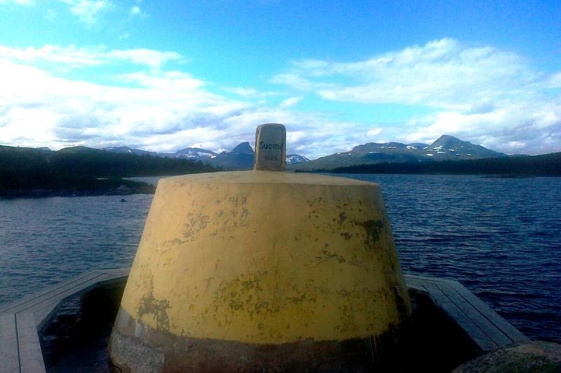
This unassuming concrete monument holds surprising significance: it’s the meeting point of Sweden, Finland, and Norway! A symbol of Scandinavian unity, the Three-Country Cairn lets visitors take a unique stroll