

Maps aren’t just for navigation! From official government maps tracking climate disasters to quirky ones charting all the Springfields in the U.S., unusual maps offer fascinating glimpses into the lesser-known side of America. Get ready to have your perceptions of the country challenged and maybe even learn something new.
From Field to Fork: Where Does Your Food Come From?
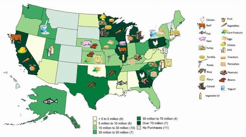
Ever wonder where those juicy strawberries or crisp apples actually originate? Turns out, a lot of our food comes from just a handful of states. The USDA’s fascinating map reveals that California, Minnesota, Illinois, Pennsylvania, and Michigan are our nation’s agricultural powerhouses. Did you know California grows a whopping 80% of the country’s strawberries, or that nearly all blueberries come from Maine?
What’s Your State Googling? Fascinating Search Trends Revealed
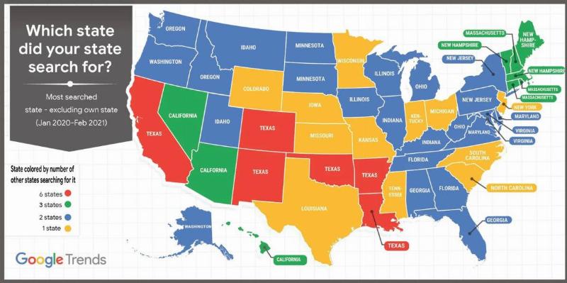
Ever wondered what other states are curious about? Google Trends offers a peek into our online fascinations. Between January 2020 and February 2021, states often searched for their neighbors (think Nevada and New Mexico looking up California). But some surprises emerge – turns out Alaska has a thing for Texas!
America’s Population Spikes: A 3D Map Reveals Where We Live
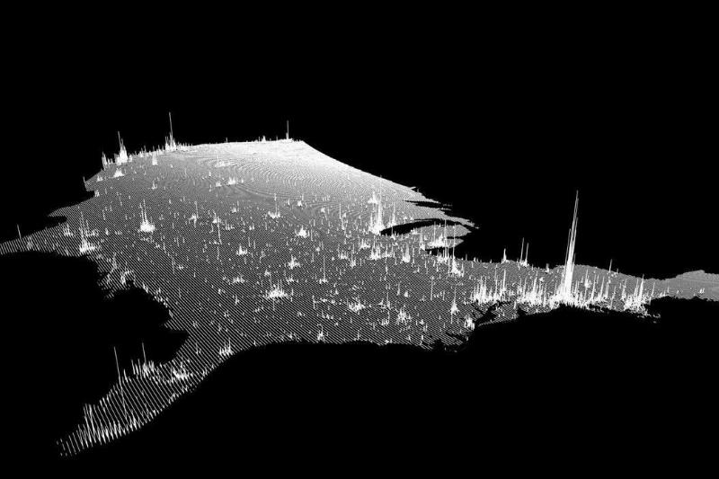
A Redditor’s innovative 3D map offers a striking visual of U.S. population density. The taller the line on the map, the more people live there. This visual reinforces what the NOAA reports: Americans cluster along the coasts. As expected, the towering population spikes belong to California, New York, and Florida.
State-on-State Shade: America’s Love-Hate Relationships Revealed
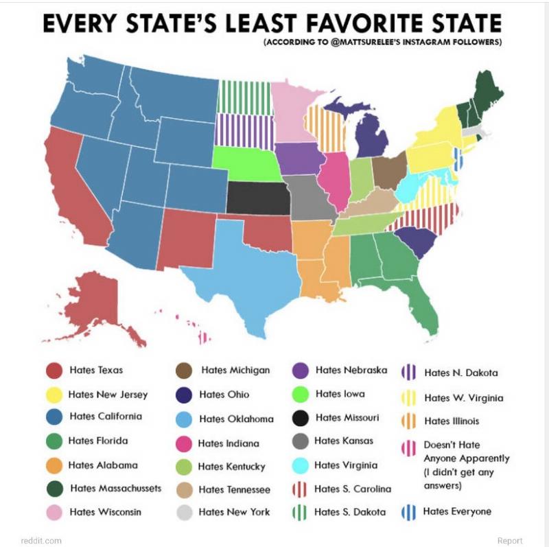
Get ready for some neighborly drama! A 2020 survey exposed the states everyone loves to hate. In a surprising twist, Floridians dislike their own sunny state the most. Californians aren’t too popular with their neighbors, and those Carolinas? They’re locked in a bitter rivalry. But the biggest losers in the popularity contest seem to be California and Texas.
Mind-Blowing Fact: More People Live in L.A. County Than These States
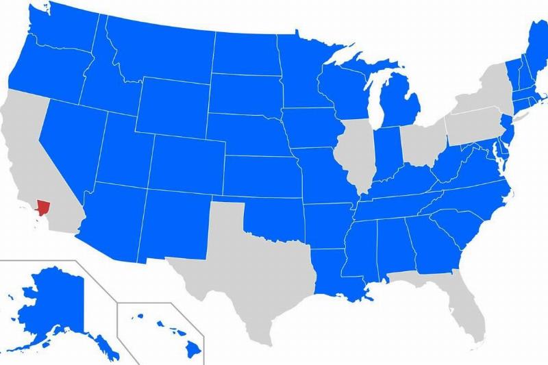
Did you know that a single California county, Los Angeles County, has a population topping over 10 million? That’s more people than live in many entire U.S. states! While California ranks third in size, it’s the most populous state with over 39 million residents, most concentrated in the southern and northern counties.
Snow Day Dreams: How Much Snow Gets Your School Cancelled?
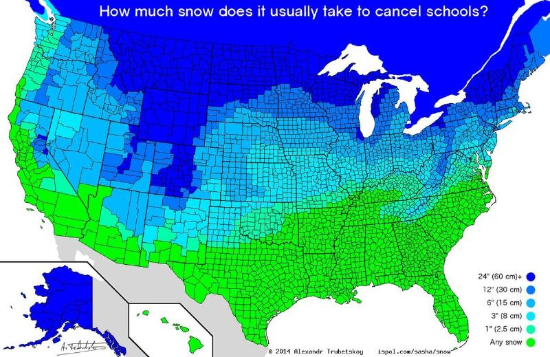
Hoping for a winter break? This fascinating map from Unofficial Networks reveals just how much snow different states need for a coveted snow day. As you’d expect, states used to blizzards need a LOT of snow for cancellations. Meanwhile, sunny places like Florida, Texas, and California get excited over even the tiniest flurry!
Your Ultimate Springfield Road Trip: Explore America, One Town at a Time
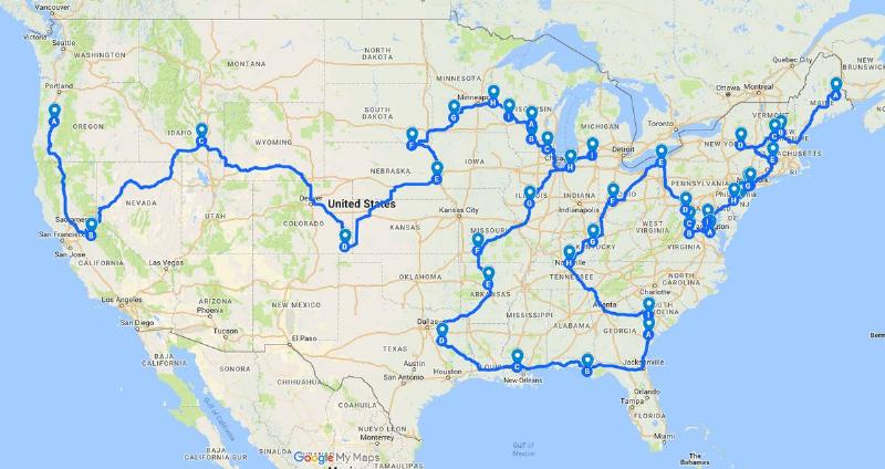
Did you know the U.S. is dotted with 45 towns named Springfield? This epic road map lets you embark on a quest to visit them all, from California to New York! Some states, like Indiana, Virginia, and Wisconsin, boast multiple Springfields. Get ready for a quirky adventure – who knows what characters (real or Simpson-inspired) you might encounter along the way!
America’s Forests: A Visual Story of Growth and Conservation
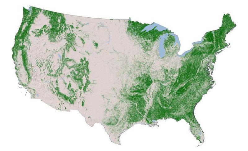
A fascinating 2014 map from the National Land Cover Database offers a snapshot of U.S. tree distribution. Lush green areas signify dense forests, while white indicates sparser tree cover. The good news? By 2015, America boasted more trees than a century prior, thanks to conservation efforts. While the numbers may continue to shift, this map serves as a reminder of the power of reforestation.
The Mississippi’s Mighty Network: 7,000 Rivers Fuel a Giant
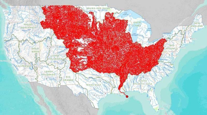
The Missouri River may be America’s longest, but the mighty Mississippi claims the title of deepest and most voluminous. Its incredible size stems from a network of 7,000 rivers flowing into its basin from across a vast swathe of the United States. This map reveals the astonishing web of waterways that ultimately feed the Mississippi, making it a true force of nature.
America’s Name Game: Mapping the Most Common Surnames
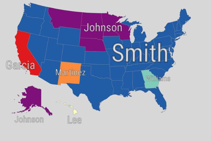
Ever wondered what the most popular last name is in your state? A fascinating 2019 map reveals the answer! “John Smith” dominates the middle of the country and East Coast. Meanwhile, California and New Mexico reflect their proximity to Mexico with a prevalence of Spanish surnames. Even seemingly simple names have diverse roots – Hawaii’s “Lee” could have Chinese, Korean, or English origins!
Spelling Bee Blunders: The Words That Stump Each State
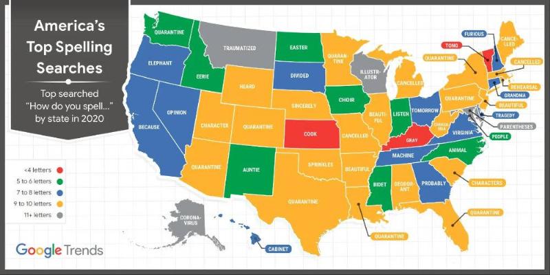
In 2020, Google Trends revealed America’s spelling weak spots in a hilarious way. Turns out, we’re not all dictionary whizzes! Most states grappled with long words like “beautiful” and “quarantine.” But Kansas, Kentucky, and Vermont hilariously struggled with four-letter words. Time to brush up on our spelling, folks!
The Percentage Of American Citizens Without Health Insurance
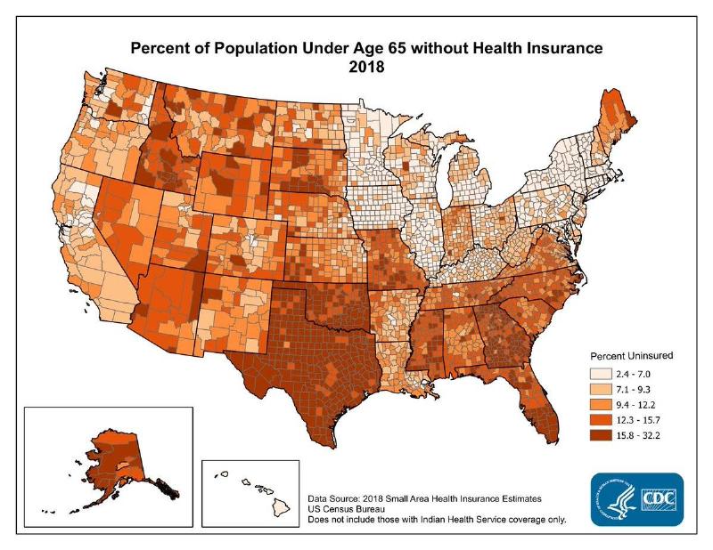
In 2018, the U.S. Census Bureau published a map with the percentage of Americans who do not have health insurance. The highest percentages (and darkest color) were between 15.8% and 32.2%.
Oklahoma and Texas have the highest number of uninsured residents, while Northeastern states like New York and Massachusetts are the most insured.
America’s Melting Pot: Where Immigrants Call Home
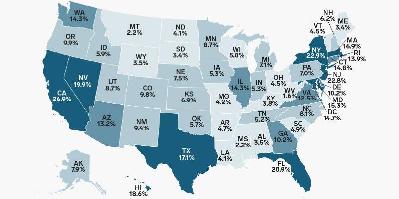
This map tells a tale of journeys and new beginnings. Shades of blue reveal where those born outside the U.S. now reside – a vibrant pattern clustered on coasts and borders. Numbers come to life: 13.7% of America’s population are immigrants, shaping the nation’s character.
The World Within America: Where Our Journeys Begin
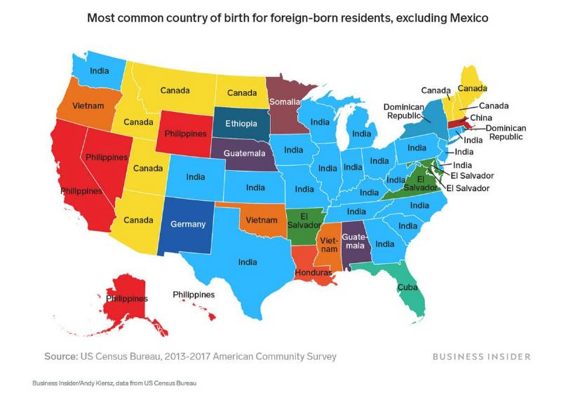
Forget borders – this map traces a tale of global connections. Each color represents a birthplace, showing how America is a mosaic of nations beyond Mexico. Dominant hues reveal India, Canada, and the Philippines… but there are countless other stories hidden within. Discover the diversity that defines the American experience.
America’s Soundscape: From Deafening Cityscapes to Peaceful Retreats
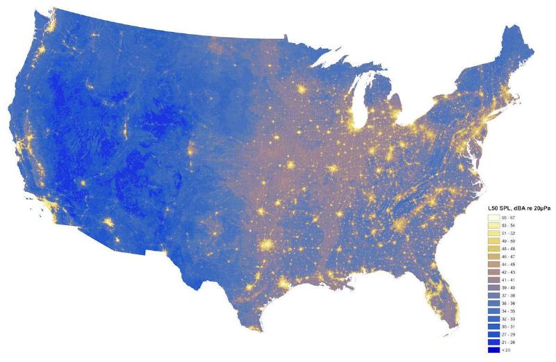
This map isn’t just about volume, it reveals a hidden threat. Blazing bright spots mark our loudest cities, where constant noise harms both wildlife and human health. Yet, amidst the din, pockets of deep quiet endure. Experience America not just with your eyes, but your ears too.